

Sarkaslampi geological trail
Sarkaslampi is one of the Saimaa Geopark destinations in Juva. The route tours the rugged nature and lake scenery and features three relics: a prehistorical quartz quarry and two rock paintings.
"The rocky areas of Ristilampi and Sarkaslampi are dominated by scarps rising 30-50m above the water and the valleys between the scarps, which illustrate the passage of fault and fracture zones in the area’s bedrock. The main type of rock in the bedrock is garnet-rich mica gneiss containing veins of granite, with larger areas of granite in some places.
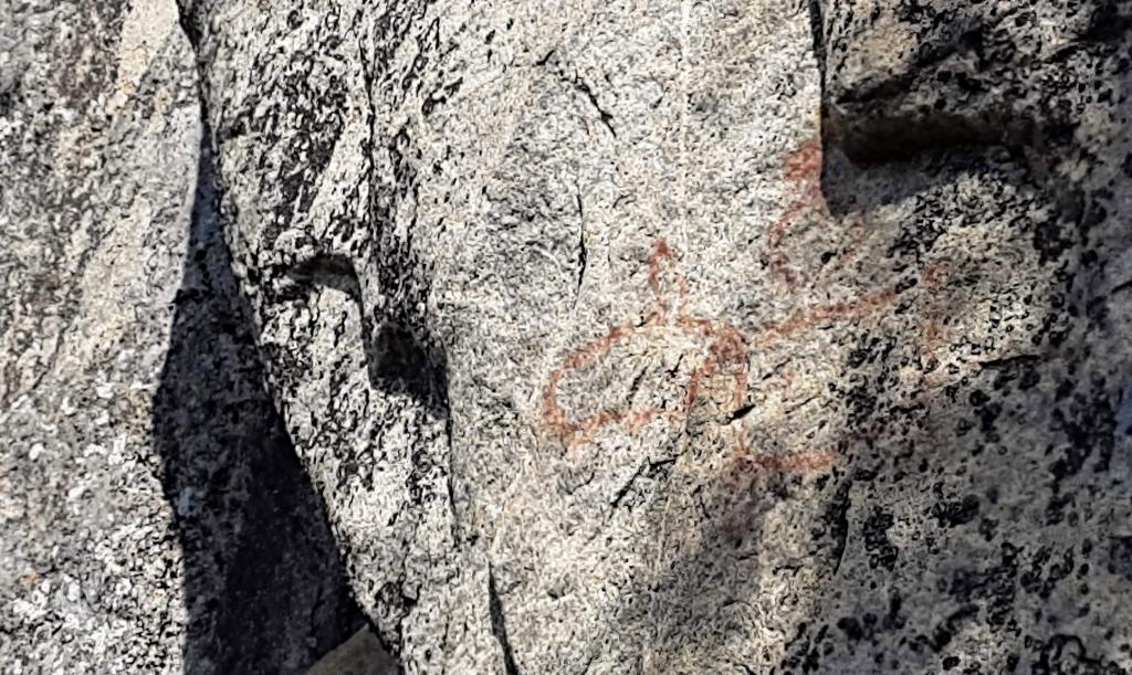
There are rock paintings in the area of Sarkaslampi depicting an elk and a boat, and there is a prehistoric quartz quarry in the quartz-rich part of a pegmatite dike on the eastern shore of Ristilampi. A curved surface typical to potholes, worn down by the melt-waters of the continental ice sheet, can also be seen above the quartz quarry.
There is a marked path along the shores of Ristilampi and Sarkaslampi ponds, in challenging terrain, leading to the prehistoric quarry and rock paintings." (quoted from Saimaa Geopark website )
More information
The map of the Sarkaslampi geological trail
How to use the map:
- You can access the map tools from the top left corner: you can switch between the previous view and the next one, and measure distance and area.
- You can browse different map levels by clicking the bottom button on the top left corner. You can access a terrain map and an orienteering map.
- The search function enables you to search destinations by name from a wider area.
- The tools on the right side of the map help you to return to the default view, zoom in and out, focus the map onto your location, and find out the location’s coordinates. The destination info shows the coordinates according to the ETRS89/~WGS84 coordinates system.
Your location on the map:
- You can view your location on the map by using the function "Keskitä kartta omaan sijaintiisi" (focus the map onto your location). The icon has a light grey navigation circle symbol on black background.
- The location tracking is activated by clicking the icon. By clicking again, you can deactivate the tracking function and remove your location from the map.
- The location is marked as a blue dot: the accuracy of the location is marked by the lighter blue circle.
- The location on the map is updated with the mobile device’s location information. If your location is outside of the map view, the view is focused on the default central location of the map.
Pictures from the trail


